
Module 1.3 – Interdital


Interdital (under development)
(Satellite-derived intertidal topography mapping)
Knowledge of the topography of the intertidal zone is crucial for predicting shallow water components of the tides. Very steep coastlines are typically more energetic and in contrast a smaller influence on the shallow water components of the tide is expected. On low-slope coasts, such as tidal flats and mangrove strips, there is a greater influence on the shallow water components of the tide.
The topography of the intertidal zone can be estimated by combining simultaneous information on the astronomical tide level and the position of the coastline, obtained by orbital optical sensors (Sagar et Al., 2017, <https://doi.org/ 10.3390/rs10030480>; Bishop-Taylor et Al., 2019, <https://doi.org/10.1016/j.ecss.2019.03.006>; Vos et Al., 2020, <https://doi.org/ 10.1029/2020GL088365>).
The methodology proposed by Bishop-Taylor et al. (2019) consists of a set of five steps (Figure 1):
- Grouping of all images collected on dates with different astronomical tide levels;
- Crop the intertidal area using the OTSU methodology (1979, <https://cw.fel.cvut.cz/b201/_media/courses/a6m33bio/otsu.pdf>) in the image in terms of standard deviation for the entire collection;
- Determination of the coastline in each image in terms of the AWEF index (Feyisa, 2014, <https://doi.org/10.1016/j.rse.2013.08.029>).
- Association of the tide level taken from tide gauge data with each coastline at the same time of collection of the satellite image.
- Construction of the digital model of the term using a set of coastlines at different elevations.
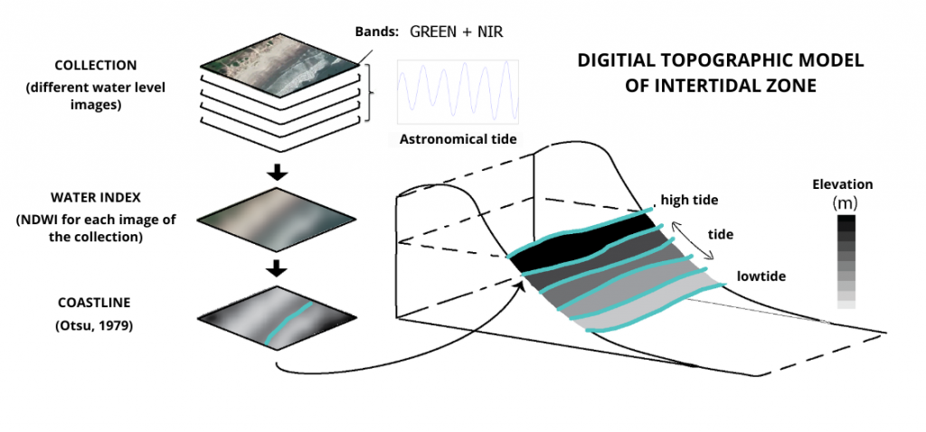
Figure 1. Theoretical schematic demonstrating the mapping of the topography of the intertidal zone (Fonte: addapted from Bishop-Taylor et al., 2019).
The methodological approach of Bishop-Taylor et al. (2019) and Costa et al. (2022, <https://doi.org/10.5194/nhess-2021-387>) is being implemented in the [Intertidal] module of the CASSIE-CoRe ® web platform, using the entire time series (seven years of observations) of the Sentinel-2 (Copernicus) satellite mission available on GEE (Google Earth Engine). It should be noted that the algorithms for cropping the area of interest, geometric correction (registration), image composition (when the area of interest covers more than one image), cloud filter, temporal filter, and automatic mapping of the coastline have already been developed within the scope of the [ShoreAnalyst] module (Almeida et al., 2021, <https://doi.org/10.1142/9789811275135_0147>).
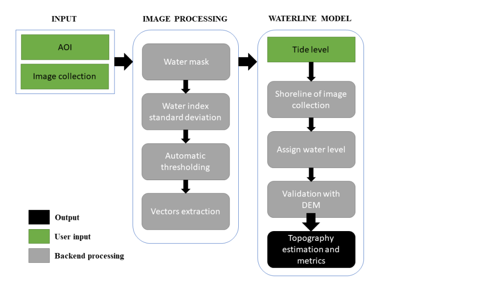
Figure 2. Intertidal module execution flowchart.
The rise of the astronomical tide will be predicted using the Oregon State University Tidal Prediction Software (OTPS) TPX08 model (Egbert; Erofeeva, 2010, 2002, <https://doi.org/10.1175/1520-0426(2002)>,<http ://volkov.oce.orst.edu/tides/global.html>). This model allows obtaining the tidal elevation for any region of the planet with a spatial resolution of 1/6° (∼18×18 km). This information will be added to Google Earth Engine (GEE), through the creation of a new asset.
The set of coastlines with associated topographic elevation (Figure 3) will be used to produce a topographic model of the intertidal zone through a linear interpolation method, the Delaunay Triangulation using the Quickhull algorithm (Shamos et al., 1985, <https://doi.org/10.1007/978-1-4612-1098-6_4>). With this model, it will be possible to analyze the slope of the beach and the extent of the intertidal zone (Figure 1), which are crucial elements for mapping the impacts of climate change in exposed and sheltered areas.
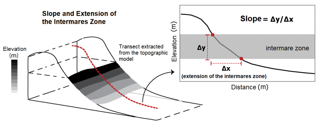
Figure 3. Representative scheme of how the slope and extent of the intertidal zone is calculated from the topographic model.

