
Module 2.1 – Shoreline – R


Shoreline – R (Requirements Gathering)
(Determination of coastline retreat due to accelerated sea level rise using empirical method)
To improve the projection quality, it is possible to add the impact of the acceleration of sea level rise to the coastline evolution rate (ELC parameter, calculated in the [Shoreline Analyst] module, described in module 1.1.). To do this, it is necessary to calculate the value of R (retreat in meters), determined using Bruun’s rule (1988,<https://www.jstor.org/stable/4297466>) modified (Eq. 1):
𝑅 = E/tan𝛽 . 𝑅𝐶 [Eq. 1]
Where tanβ is the slope of the beach (data accessible through the global coastal zone slope database (Athanasiou et al., 2019, <https://doi.org/10.5194/essd-11-1515-2019>) ; or through the [Intertidal] module, and the correction coefficient for sea level acceleration (Ferreira et al. 2006, <https://doi.org/10.1016/j.csr.2005.12.016>; Klein et al 2016, <https://doi.org/10.2112/JCOASTRES-D-15-00164.1>; Vousdoukas et al. 2020, <https://www.nature.com/articles/s41558-020-0697-0> ), and RC the sea level value for future scenarios (data obtained through the NASA/IPCC platform with recent sea level projections).
This set of calculations will be carried out “on-the-fly” on the GEE platform following the user’s request. The calculations will be performed along a set of transects perpendicular to the coastline and in the end the result will be the set of future coastlines (one for each scenario) in a vector format. The position of the future coastline (Ln, where n is the year of the projection) will be the result of the sum between the position of the most recent coastline (L0), obtained through the [Shoreline Analyst] module, the ELC and R , as demonstrated in Equation 2.
Ln = L0 + ELC + R [Eq. 2]
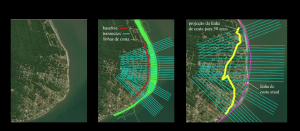
Figure 1. Illustration of the logical sequence of determining the position of the future shoreline (example demonstrated for 50 years in the future) using an empirical approach.
Figure 1 shows a demonstration of determining the position of the future coastline using Eq. 2. This empirical approach is being implemented in CASSIE-CoRe and can be applied to any coastal region on the planet.

