
Module 1.2 – C-Squeeze


C-Squeeze (In test)
(Methodology for analyzing the “Coastal Squeeze” process in estuarine coastal areas)
The coastal mangrove ecosystem is an important provider of ecosystem services by attenuating incident wave energy and protecting the coast from erosion and flooding, by favoring sedimentation and vertical growth of the soil, thus protecting the coast from sea level rise, or even as a mechanism for trapping and retaining carbon from the atmosphere.
These functions are extremely important considering the period of climate change we are currently facing. As it is a fragile and complex ecosystem, the mangrove needs space to move around so that it can fully maintain its functions and, thus, be able to adapt to changes such as the acceleration of sea level rise, migrating to the continental side. For this to occur, however, a horizontal accommodation space must be maintained unaltered (without the presence of impermeable barriers such as human infrastructure), thus allowing colonization in a natural way. However, the disordered occupation of the coast and urbanization in the mangrove’s continental accommodation range can result in blocking mangrove migration, causing it to suffer a process of coastal compression, known as Coastal Squeeze (Pontee, 2013, <https:/ /doi.org/10.1016/j.ocecoaman.2013.07.010>).
The C-Squeeze module is being developed on the CASSIE-CoRe® web platform to assess the potential for coastal squeeze in any estuarine coastal region on the planet. The module will use the results obtained through the Shore-R module – future position of the coastline considering the acceleration of sea level rise; and thus, quantify the potential loss of mangrove area due to oceanic processes. Subsequently, the results of the EUS-Urban module – future projection of the position of the urban front, will allow quantifying the reduction in the accommodation area on the continental side, and consequently evaluating the potential for “coastal squeeze” in the area of interest (Figure 1).
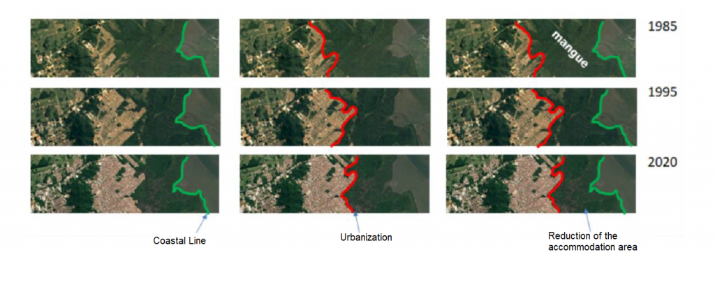
Figure 1. Sequence of satellite images obtained in different years in the coastal zone of Babitonga Bay, demonstrating the evolution of the urban front and consequently reduction of the horizontal accommodation space of the mangrove ecosystem.

