
Module 2.3 – Shoreline – S


Shoreline – S (Requirements Gathering)
(Coastline forecast at multi-time scales using reduced complexity model)
With large-scale human interventions and climate change unfolding as it does now, changes in coastal morphology on scales of decades are not limited to incremental modifications of systems that are fixed in their overall geometry, but often show significant changes. in the layout that can be catastrophic for populations living in previously safe areas. This poses major challenges that are difficult to address for existing numerical models. Therefore, in this project, it is proposed to transcribe and incorporate into the CASSIE-CoRe® web platform, the [Shoreline-S] model code (Roelvink et al. 2020, <https://doi.org/10.3389/fmars.2020.00535> ), which is a new coastline model of reduced complexity, capable of describing large coastal transformations based on relatively simple principles such as the gradient of sediment transport along the coast as a result of the curvature of the coastline, or due to the angle wave incidence, as well as considering processes such as the separation or union of sandy barriers along the coast or even blockage in littoral drift due to the presence of hard structures. Rock parts or structures, which can block wave energy and/or sediment transport along the coast, can be integrated into the simulation, making it possible to apply this model to a large set of coastal environment possibilities (Figure 1).
Furthermore, the model has the ability to represent various morphodynamic behaviors including shoreline undulations and spur formation, migratory islands, merging of coastal forms, salients and tombolos. The [Shoreline-S] model is open source, available at www.shorelines.nl.
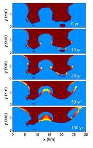
Figure 1. Example of the prediction of the evolution of the coastline on a decadal scale carried out through the application of the Shoreline-S model (Roelvink et al., 2020).

